Arrival!
The cliff-edge trail and the precipice it rode on curved to the left, and
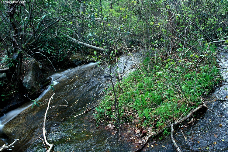
I was gratified when it led me to this stream flowing over the stone. This photograph suggests the delicacy of
cataract vegetation.
The rock was inclined at perhaps 30 degrees (pi/6 radians for the geeks) and the water flow was brisk,
yet somehow an island of plant life and soil maintained a foothold.
How does the apron of vegetation hang on?
Is it the combined effort of countless root tips grasping tiny bumps in the smooth rock surface? Or is
the entire mat of vegetation slowly sliding down the rock? Perhaps
chunks fall off the bottom, while new growth appears at the top? Does this vegetation mat get damaged by seasonal flood
conditions? Is this habitat degrading because of pollution depositions? I have so many questions!
I was gratified to see that this site was under active monitoring and perhaps management. The evidence was clear--pin-flags
here and there, and a network of faint trails in the surrounding vegetation leading to various access points. I hope
good research comes out of this, especially if it can be used to steward this site for the future.
I proceeded carefully during my stay at this site, and made sure I didn't step on the vegetation; I
imagine that a
single footstep could cause so much damage that an entire section of the bog
could detach and wash away. This meant I had to stay on the slippery rock surface--which significantly limited my
exploration options--but it was crucial that I made no impact.
And yes, there are some pitcher plants in that vegetation, but they were not very photographable. So I explored other parts
of the stream, looking for more plants to photograph.
![]()
![]()