Home Sensing Primer Glossary Physics Related Technologies Acknowledgements
Image Size, Spatial Coverage, and Spatial Resolution
Consider the black and white images below of a pitcher plant (Sarracenia oreophila, a federally endangered pitcher plant native to Alabama, Georgia, and North Carolina, and probably extirpated from Tennessee). The image dimension of the high-resolution version on the left is 300 pixels wide by 400 pixels tall (or more simply written, 300×400 pixels). If you wanted a camera that could capture an image as nicely smooth-grained and with as high resolution as this, it would require 120,000 pixels (i.e. 300×400). That is a lot of detectors, and they are recording many points of brightness data!
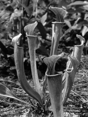 High resolution image. |
 Medium resolution image. |
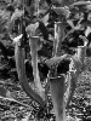
 Low resolution image. |
Suppose your budget says you can only afford a device that can record one-fourth as many pixels on an image side. The output
image produced such a device would have an image size of 75×100=7,500 pixels, and would look like the medium-resolution
version shown on this page. Since the images both cover the same amount of area, they are said to have the same amount of spatial coverage.
(As another example, two aerial images of the ground that have different image sizes but which both span the same 4 km2 area have the
same spatial coverage.) However, the spatial resolution (also called physical resolution) is obviously not as great as in the
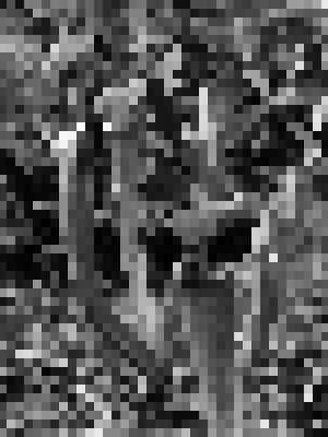
high-resolution version. Suppose additional budget cuts say that your image size must be even smaller, i.e. only about 1900 pixels
(i.e. 38×50=1,900 pixels). With the same spatial coverage, your spatial resolution must decrease to the (ugly!)
low resolution version to the above right.
Note that bigger is not always better. If your project's goal was to identify photographs of pitcher plants, with a little
practice either the high-resolution or the medium-resolution versions would have been adequate (while the low resolution version would be
useless). But since the image size of the medium-resolution is only 1/16th that of the high-resolution
(e.g. 7,500 pixels/120,000 pixels=1/16), the images are much easier to deal with. You can fit more on a disk, your software can display
them faster with fewer crashes, and your printer can print them faster. A frequent cautionary note in remote sensing is to avoid getting
too much data! A plot of land 10 km on a side, imaged at 1 meter spatial resolution, will result in an unmanageably large image size of
100,000,000 pixels! If you can get by with only 10 meter resolution, your image will be only 1,000,000 pixels--a significant improvement
in file manageability!